Precinct Maps Created From Voter Records
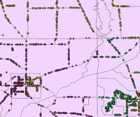 For a while, I have commented on the fact that the media will need better geographic detail to more closely examine the geography of politics and in particular the precincts that will sway the vote in an election. Word comes from Farallon Geographics that they were contracted by National Committee for an Effective Congress (NCEC) to "complete the first multi-state, spatially-enabled GIS election precinct data set that covered almost a dozen battleground states." The work entailed compiling over 20 million voter records supplied by the Democratic National Committee. I've asked Farallon to supply more details on how the records were processed to define these precincts because as the graphic at right shows, the raw data is in the form of point records. Oracle Spatial was used to process the point data. Of course the other issue is what this point data represents? Are these actual voters and if so, is there an issue with privacy of these records? So, will the media get these data? More details to follow.
UPDATE: Farallon Geographics contacted me today to say that "There is no mapping of name or personal information to location. Farallon did not have access to any personal data – just geocoded points with precinct information (not actual addresses)."
Comments